
Export Polygons OGR
The Export Polygons OGR functionality enables you to export polygons of your Isatis.neo project into a vector file (dxf from AutoCAD, shapefile from ESRI, kml or GeoJSON). This functionality makes easier polygon exchanges between Isatis.neo projects, the output file can be indeed imported in another Isatis.neo project through the Vector File Import. Polygon geometry is exported by default. You can also choose to export associated variables, if any are available.
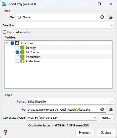
-
Input:
- File: Click the folder icon to open a Data Selector to select the polygon file you want to export. The polygon file can also be dragged and dropped directly from the Data tab.
- Selection: You can define an optional Selection variable to filter polygons which will be exported.
- Export all variables: By default the toggle Export all variables is activated. All the variables contained in the selected polygon file will be exported. If you want to export only a part of the variables, untick the toggle to access the Variables list and select the variables you want to export. Any kind of variable can be exported from Isatis.neo: numerical, selection, categorical, macro variables. Variables will be exported using the unit and display format.
Note: The implicit variables (Sample Number, Name, ...) do not appear in the Variables list but they are automatically exported.
Note: If the output file is a dxf from AutoCAD, only the geometry will be exported, even if you specified variables.
-
Output:
-
Format: Select the output format: AutoCAD DXF (.dxf), ESRI Shapefile (.shp), Keyhole Markup Language (.kml) or GeoJSON.
Note: The Keyhole Markup Language (.kml) and GeoJSON formats are only available if the project has a defined coordinate system (i.e. not the User Local System).
- File: Enter the output file, click the folder icon to pop up a window file selector. The output extension is automatically set depending on the selected output format.
-
Coordinate system: Select in the catalog the coordinate system of your output vector file. The most common coordinate systems are preselected. If the system you are looking for is not in this list, click More. For more information about how to define a coordinate system, please refer to the Coordinate System Selector section.
Note: By default the project coordinate system is preselected.
Note: If the output file is a KML file or a GeoJSON, this field is greyed out and the defined coordinate system will be WGS84.
-
- Click Export to end the export task.
- Press Close to abort the export task.
